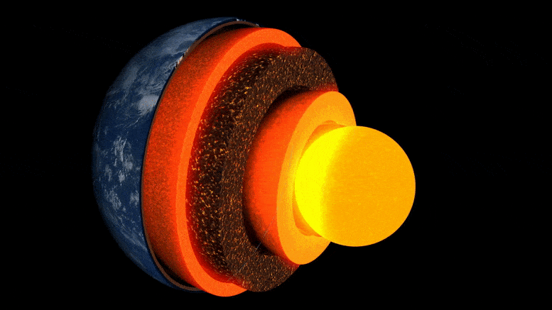
Animación de capas terrestres.
Una nueva investigación dirigida por la Universidad de Cambridge es la primera en obtener una «imagen» detallada de una bolsa de roca inusual en la capa límite con el núcleo de la Tierra, a unos 3.000 kilómetros por debajo de la superficie.
La misteriosa área de roca, ubicada casi directamente debajo de las islas hawaianas, es una de varias zonas de velocidad ultrabaja, llamada así porque las ondas sísmicas disminuyen su velocidad a medida que pasan a través de ellas.
La investigación, publicada el 19 de mayo de 2022 en la revista Comunicaciones de la naturalezaes el primero en revelar en detalle la compleja variabilidad interna de uno de estos bolsillos, arrojando luz sobre el paisaje del interior profundo de la Tierra y los procesos que operan allí.
«De todas las características en el interior de la Tierra, estas son las más fascinantes y complejas». — zhi li
“De todas las características profundas del interior de la Tierra, estas son las más fascinantes y complejas. Ahora tenemos la primera evidencia sólida que muestra su estructura interna: es un verdadero hito en la sismología de la tierra profunda», dijo el autor principal Zhi Li, estudiante de doctorado en el Departamento de Ciencias de la Tierra de Cambridge.
El interior de la Tierra tiene capas como una cebolla: en el centro está el núcleo de hierro y níquel, rodeado por una capa gruesa conocida como manto, y encima una fina capa exterior: la corteza en la que vivimos. Aunque el manto es roca sólida, está lo suficientemente caliente como para fluir extremadamente lentamente. Estas corrientes de convección interna proporcionan calor a la superficie, impulsando el movimiento de las placas tectónicas y alimentando las erupciones volcánicas.
Los científicos utilizan las ondas sísmicas de los terremotos para ‘ver’ debajo de la superficie de la Tierra: los ecos y las sombras de estas ondas revelan imágenes similares a las de un radar de la topografía interior profunda. Pero hasta hace poco, las ‘imágenes’ de estructuras en el límite entre el núcleo y el manto, un área clave de interés para estudiar el flujo de calor interno de nuestro planeta, eran granulosas y difíciles de interpretar.
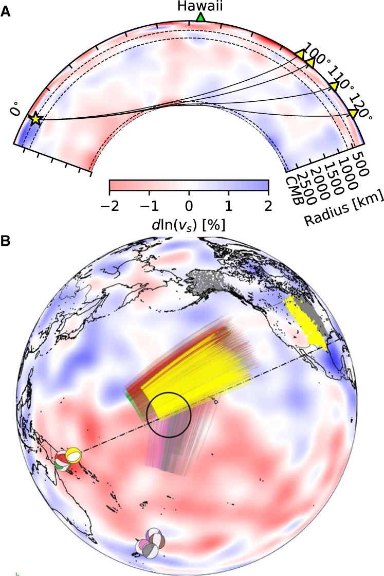
Trayectorias de rayos Sdiff y eventos utilizados en este estudio. A) Sección transversal que atraviesa el centro de la zona de ultra baja velocidad de Hawái, que muestra trayectorias de rayos de onda Sdiff a 96°, 100°, 110° y 120° para el modelo terrestre 1D PREM. Las líneas discontinuas de arriba a abajo marcan los 410 km, 660 km de discontinuidad y 2791 km (100 km por encima del límite entre el núcleo y el manto). B) Eventos y trayectorias de rayos Sdiff en el modelo de tomografía de fondo SEMUCB_WM1 a 2791 km de profundidad. Balones de playa de eventos trazados en diferentes colores, incluidos 20100320 (amarillo), 20111214 (verde), 20120417 (rojo), 20180910 (morado), 20180518 (marrón), 20181030 (rosa), 20161122 (gris), estaciones (triángulos) y radio Trayectorias de ondas Sdiff a una profundidad de perforación de 2791 km en el manto inferior utilizadas en este estudio. El evento utilizado en el análisis a corto plazo está resaltado en amarillo. La ubicación propuesta de la ULVZ se muestra en un círculo negro. La línea discontinua muestra la sección transversal trazada en A. Crédito: Nature Communications, DOI: 10.1038/s41467-022-30502-5
Los investigadores utilizaron los últimos métodos de modelado numérico para revelar estructuras a escala de kilómetros en el límite entre el núcleo y el manto. Según el coautor Dr. Kuangdai Leng, quien desarrolló los métodos mientras estaba en la[{» attribute=»»>University of Oxford, “We are really pushing the limits of modern high-performance computing for elastodynamic simulations, taking advantage of wave symmetries unnoticed or unused before.” Leng, who is currently based at the Science and Technology Facilities Council, says that this means they can improve the resolution of the images by an order of magnitude compared to previous work.
The researchers observed a 40% reduction in the speed of seismic waves traveling at the base of the ultra-low velocity zone beneath Hawaii. This supports existing proposals that the zone contains much more iron than the surrounding rocks – meaning it is denser and more sluggish. “It’s possible that this iron-rich material is a remnant of ancient rocks from Earth’s early history or even that iron might be leaking from the core by an unknown means,” said project lead Dr Sanne Cottaar from Cambridge Earth Sciences.

Conceptual cartoons of the Hawaiian ultra-low velocity zone (ULVZ) structure. A) ULVZ on the core–mantle boundary at the base of the Hawaiian plume (height is not to scale). B) a zoom in of the modeled ULVZ structure, showing interpreted trapped postcursor waves (note that the waves analyzed have horizontal displacement). Credit: Nature Communications, DOI: 10.1038/s41467-022-30502-5
The research could also help scientists understand what sits beneath and gives rise to volcanic chains like the Hawaiian Islands. Scientists have started to notice a correlation between the location of the descriptively-named hotspot volcanoes, which include Hawaii and Iceland, and the ultra-low velocity zones at the base of the mantle. The origin of hotspot volcanoes has been debated, but the most popular theory suggests that plume-like structures bring hot mantle material all the way from the core-mantle boundary to the surface.
With images of the ultra-low velocity zone beneath Hawaii now in hand, the team can also gather rare physical evidence from what is likely the root of the plume feeding Hawaii. Their observation of dense, iron-rich rock beneath Hawaii would support surface observations. “Basalts erupting from Hawaii have anomalous isotope signatures which could either point to either an early-Earth origin or core leaking, it means some of this dense material piled up at the base must be dragged to the surface,” said Cottaar.
More of the core-mantle boundary now needs to be imaged to understand if all surface hotspots have a pocket of dense material at the base. Where and how the core-mantle boundary can be targeted does depend on where earthquakes occur, and where seismometers are installed to record the waves.
The team’s observations add to a growing body of evidence that Earth’s deep interior is just as variable as its surface. “These low-velocity zones are one of the most intricate features we see at extreme depths – if we expand our search, we are likely to see ever-increasing levels of complexity, both structural and chemical, at the core-mantle boundary,” said Li.
They now plan to apply their techniques to enhance the resolution of imaging of other pockets at the core-mantle boundary, as well as mapping new zones. Eventually, they hope to map the geological landscape across the core-mantle boundary and understand its relationship with the dynamics and evolutionary history of our planet.
Reference: “Kilometer-scale structure on the core–mantle boundary near Hawaii” by Zhi Li, Kuangdai Leng, Jennifer Jenkins and Sanne Cottaar, 19 May 2022, Nature Communications.
DOI: 10.1038/s41467-022-30502-5
/cloudfront-ap-southeast-2.images.arcpublishing.com/nzme/C4AZRMP23VBVZO7MXNVDMHRXAQ)